Discuss the IRC classification of roads?
IRC Classification of Roads:
1. National Highways (N.H.)
2. State Highways (S.H.)
3. Major District Roads (M.D.R.)
4.Other District Roads (O.D.R.)
5. Village Roads (V.R.)
1. National Highways: The main highways running through the length and breadth of the country connecting state capital, ports, foreign highways, large towns, etc. are known as National Highways.
These are of national importance for strategic, and administrative, and other purposes.
These highways constitute the main arteries of road transport in the country.
All the national highways are assigned their respective numbers.
The highway connecting Amritsar-Ambala-Delhi is denoted as NH-1.
2. State Highways: The highways connecting district headquarters and important cities within the state or connecting them with National Highways of adjacent states are known as state Highways.
These highways serve as the main arteries of traffic to and from district roads.
These are also considered as the main arteries of commerce by road within a state.
3. Major District Roads: The important roads with the district serving areas of production and markets and connecting these with each other or with highway and railways are known as Major District Roads.
These roads have roughly the same specification as the state highways.
4. Other District Roads: Other district roads are the roads serving rural areas of production and providing them with outlets to Tehsil headquarter market centers etc.
These roads have somewhat lower specifications than major district roads.
5. Village Roads: Village roads are roads connecting a village or a group of villages with each other or with the nearest district road, main highway, railway, etc.
These roads are very important from the point of view of rural area development.
The construction and maintenance of these roads are the responsibility of the local district authority.
What are Road Geometrics? How they are classiffied?
Road geometrics are the elements of a road which are visible to road users. Road geometrics provide optimum efficiency in traffic operation with maximum safety at reasonable çost.
Every Oad user wants to reach his destination safely and in the shortest possible time In order to fulfill these requirements physical features of a road such as pavement width, the width of formation, right wy curve, etc play a major role while designing a road.
The success and failure of road 0onstruction depend mostly upon the physical features of the road.
Road Geometrics
Road geometrics can be broadly classified under the following headings:
1. Cross-section elements
2. Sight distance considerations
3. Horizontal and vertical alignments
4. Intersection elements
what do you mean by road right of way? Give the IRC recommendation of standard land width for various categories of roads also.
Right of Way: Right of way is the area of land acquired and reserved for construction and development of road, along its alignment.
The width of this acquired land is called land width and depends upon the width of the formation, the slope of cutting and embankment, depth of cutting and banking, minimum sight distance on horizontal curves, drainage system, and also on the importance of the road and possible future development.
A minimum land width has been prescribed for each category of road.
The IRC recommended values of standard width for various categories of roads in rural and in different terrains are given in Table 2.1
At the time of acquiring land for a right of way it is desirable to acquire more width of land as the cost of adjoining land invariably increases very much, soon after the construction of new highway and also roadside development starts taking place marking it difficult to acquire more land later on.
In order of reserve sufficient space for the future development of the road, it is desirable to control the building construction activities on either side of the road boundary, beyond the land width acquired for the road. It is, therefore, necessary to disallow the building activities up to ‘building lines’ with sufficient setback from the road boundary.
Further, it is also desirable to exercise control on the nature of building up to setback distance up to the ‘control lines’
Write a short note on the following: a) Formation width b) Width of Pavement
a) Formation Width or Roadway Width: Formation width is the sum of widths of carriageway or pavement, shoulders, and separators if any. It is the width of the highway embankment or the bottom width of the highway cutting excluding the side drain. The formation width for different categories of roads as finalized by the I.R.C. is given in.
b) Width of Pavement: Carríageway is the width of the roadway constructed for movement of vehicular traffic Carriageway width depends on the width of the traffic lane and the number of lanes required.
The number of lanes required in a highway depends on the predicted traffic volume and the traffic capacity of each lane.
The lane width required is calculated on the basis of the width of the vehicle and the minimum side clearance required for safe driving.
As per IRC specifications, the maximum width of a vehicle is 2.44 m and the carriageway width for single lane traffic is 3.75m.
What is Camber? What is its necessity? What are the different shapes used for providing camber?
Camber is the transverse slope provided to the road surface to drain off the rainwater from the road surface. It is also called cross-slope. On the straight roads, a camber is provided by raising the center of the carriageway with respect to the edges, thus forming the highest point or crown on the centerline of the carriageway.
A horizontal curve camber is provided by raising the outer edge of the carriageway instead of raising the center.
The rate of camber is usually designed by 1 in n which means that the transverse slope is in the ratio of 1 vertical to n horizontal. Amount of center mainly depends on:
1. Type of road
2. Amount of rainfall
Camber should be just sufficient for the efficient drainage of rainwater from the road surface.
For pavements like cement concrete or bituminous concrete, flat camber is enough. For surface like water-bound macadam or earth road steeper camber is required as these allow surface water to get into the subgrade soil.
Excessive camber is not desirable because of the following reasons:
(I) Rapid flow of water results into the formation of crosscuts.
(II) Problems of topping over of highly laden bullock carts.
(III) Due to excessive camber there is the tendency of most of the vehicles to travel along the centerline.
(iv) During overtaking operation, vehicles tend to drag, causing uncomfortable conditions.
(V) Faster wear & tear of the road surface along the edges than the central part.
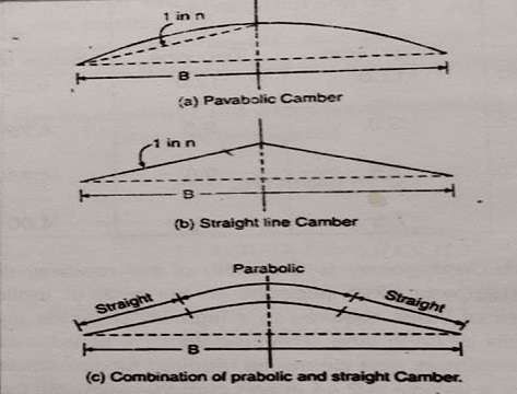
Cambers are generally provided in three shapes-Parabolic, Straight line, and a combination of straight and parabolic shapes.
Parabolic camber provided a flatter profile at the middle and steeper towards the edges, which is preferred for fast-moving vehicles.
Also, Read That.
It’s really good and educational